
Property-level coastal erosion
risk for every UK address
Erosion scores, encroachment timelines, and coastal defence intelligence per UPRN across all four UK nations.
Engineered from national coastal monitoring programmes


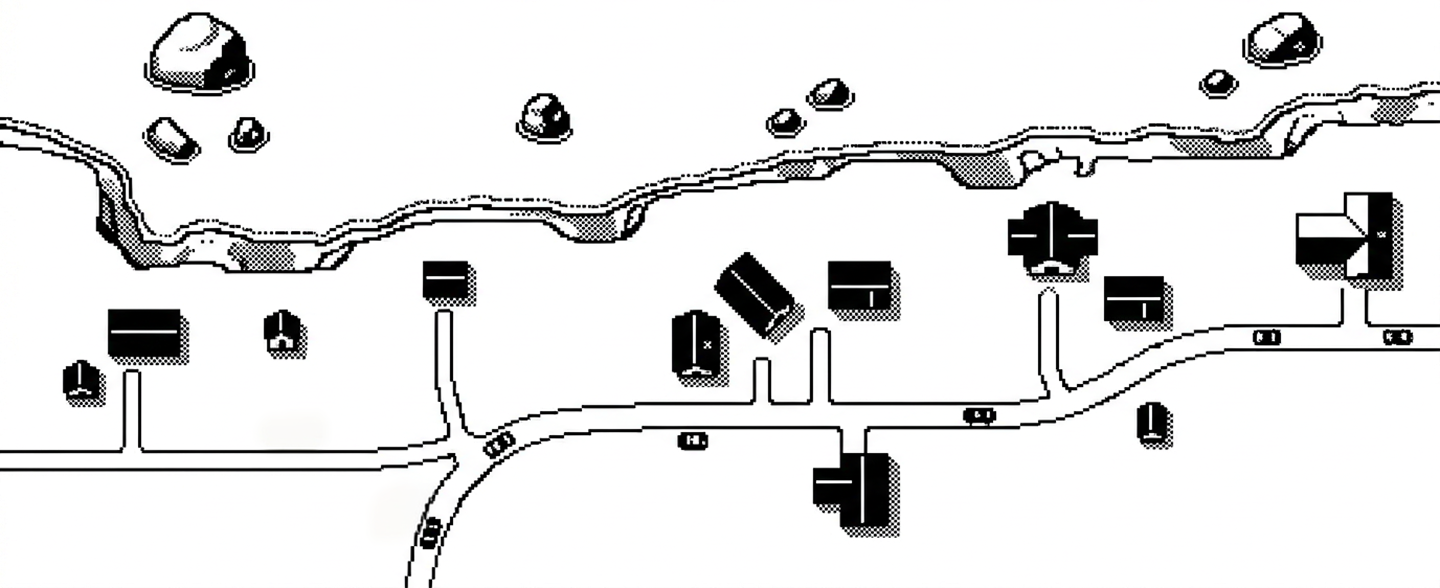
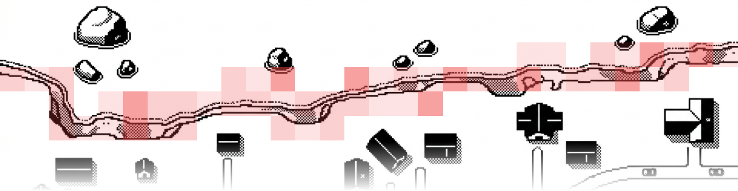
UK coastline modelled
0 km
Compliance-ready data
Meet PRA SS5/25 and SS1/23 requirements with data that maps to every obligation, so you can close your June 2026 compliance gap without a custom build.

Property-level scoring
Erosion risk scored per UPRN, not by postcode or local authority. Every SS5/25 submission reflects the actual distance and encroachment probability for each property.
Confidence grades
Every property receives a confidence grade from A to D based on data quality and model agreement, meeting SS5/25 data quality disclosure requirements.
Four climate scenarios
RCP 2.6, 4.5, and 8.5 plus Defence Stress. Outputs map directly to NGFS scenario frameworks for regulatory reporting.
Defence Stress scenario
RCP 8.5 at the 95th percentile combined with coastal defence failure. The severe-but-plausible tail risk scenario for PRA stress testing and ICAAP submissions.
Forward projections to 2105
Encroachment probabilities at 5, 10, 25, and 50 years. England projections to 2055 and 2105. Scotland decadal to 2100. Wales and NI at matching derived horizons.
Provenance chain
Every score traces back to NCERM, Dynamic Coast, NRW, or Ulster DSAS with dataset versions and contributing sources included in every response.
Collateral impairment assessment
Time-to-encroachment within mortgage term and encroachment probability at four horizons, giving credit committees direct signals on collateral risk.
Full model governance
Built on government benchmarks combined with LIDAR terrain measurement, defence fragility modelling, and sea-level rise analysis. Full methodology documentation and auditable pipeline for SS1/23.
Property-level scoring
Erosion risk scored per UPRN, not by postcode or local authority. Every SS5/25 submission reflects the actual distance and encroachment probability for each property.
Four climate scenarios
RCP 2.6, 4.5, and 8.5 plus Defence Stress. Outputs map directly to NGFS scenario frameworks for regulatory reporting.
Forward projections to 2105
Encroachment probabilities at 5, 10, 25, and 50 years. England projections to 2055 and 2105. Scotland decadal to 2100. Wales and NI at matching derived horizons.
Collateral impairment assessment
Time-to-encroachment within mortgage term and encroachment probability at four horizons, giving credit committees direct signals on collateral risk.
Confidence grades
Every property receives a confidence grade from A to D based on data quality and model agreement, meeting SS5/25 data quality disclosure requirements.
Defence Stress scenario
RCP 8.5 at the 95th percentile combined with coastal defence failure. The severe-but-plausible tail risk scenario for PRA stress testing and ICAAP submissions.
Provenance chain
Every score traces back to NCERM, Dynamic Coast, NRW, or Ulster DSAS with dataset versions and contributing sources included in every response.
Full model governance
Built on government benchmarks combined with LIDAR terrain measurement, defence fragility modelling, and sea-level rise analysis. Full methodology documentation and auditable pipeline for SS1/23.
Coastal erosion in one call.
Property-level erosion scores, encroachment timelines, and defence intelligence across all four UK nations in a single API call.
Erosion risk scores
Property-level erosion scores with encroachment timelines and confidence grades across all four UK nations.
Five-band composite score
Every coastal property receives a risk band from 1 Negligible to 5 Critical, with a confidence grade (A to D) included on every score.
Encroachment probability at 5, 10, 25 and 50 years
Assess exposure across mortgage terms and insurance periods with time-horizon probabilities you can act on directly.
Uncertainty bands on all estimates
Every encroachment estimate includes p5, p50, and p95 values so you see the full range of outcomes, not a single point estimate.
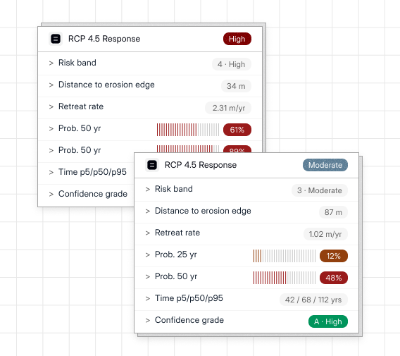
RCP 4.5 Response
High
>
Risk band
4 · High
>
Distance to erosion edge
34 m
>
Retreat rate
2.31 m/yr
>
Prob. 50 yr
61%
>
Prob. 50 yr
89%
>
Time p5/p50/p95
11 / 19 / 28 yrs
>
Confidence grade
A · High
RCP 4.5 Response
Moderate
>
Risk band
3 · Moderate
>
Distance to erosion edge
87 m
>
Retreat rate
1.02 m/yr
>
Prob. 25 yr
12%
>
Prob. 50 yr
48%
>
Time p5/p50/p95
42 / 68 / 112 yrs
>
Confidence grade
A · High
Four climate scenarios, one consistent schema
Four climate scenarios from Paris-aligned to tail-risk, all returning the same fields for direct comparison.
Present-day to 2105 projections
Three RCP pathways from Paris-aligned (RCP 2.6) to high emissions (RCP 8.5), mapped directly to NGFS frameworks for regulatory reporting.
Defence stress scenario
RCP 8.5 at the 95th percentile combined with defence failure. The severe-but-plausible tail-risk scenario designed for PRA stress testing.
One schema across all scenarios
Every scenario returns identical fields so you can compare directly and switch between pathways without any data-handling changes on your side.
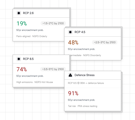
RCP 2.6
19%
~1.5–2°C by 2100
50yr encroachment prob.
Paris-aligned · NGFS Orderly
RCP 4.5
48%
~2.5–3°C by 2100
50yr encroachment prob.
Intermediate · NGFS Disorderly
RCP 8.5
74%
~3.5–5°C by 2100
50yr encroachment prob.
High emissions · NGFS Hot House
Defence Stress
RCP 8.5 @ 95th + defence failure
91%
50yr encroachment prob.
Tail risk · PRA stress testing
Coastal defence intelligence
Not every exposed property is unprotected. Query defence type, condition, and failure probability alongside the erosion score.
Defence dependency score
How much the property's risk band depends on maintained defences, with the long-term Shoreline Management Plan policy included for each frontage.
Defence failure probability
Likelihood of failure under each scenario's loading conditions, derived from asset condition, LIDAR-verified crest levels, and projected sea-level rise.
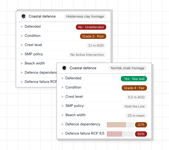
Coastal defence
Holderness clay frontage
>
Defended
No · Undefended
>
Condition
Grade 2 · Poor
>
Crest level
2.1 m AOD
>
SMP policy
No Active Intervention
>
Beach width
4 m mean
>
Defence dependency
0.04
>
Defence failure RCP 8.5
78%
Coastal defence
Norfolk chalk frontage
>
Defended
Yes · Sea wall
>
Condition
Grade 4 · Fair
>
Crest level
5.2 m AOD
>
SMP policy
Hold the Line
>
Beach width
23 m mean
>
Defence dependency
0.71
>
Defence failure RCP 8.5
50%
Full provenance, four nations
Every score traces back to a named government source across all four nations, normalised into one schema for portfolio-wide analysis.
Auditable provenance chain
Every score traces back to a named government source. Contributing sources and dataset versions are included in every response.
Cross-nation normalisation
All four national programmes normalised into one schema. Run a single analytical pass across a UK-wide portfolio without nation-specific data handling.
Quarterly updates
High-activity and defence-dependent segments re-scored quarterly. Full national refresh annually, aligned to government dataset release cycles.
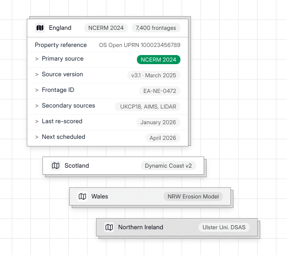
England
NCERM 2024
7,400 frontages
Property reference
OS Open UPRN 100023456789
>
Primary source
NCERM 2024
>
Source version
v3.1 · March 2025
>
Frontage ID
EA-NE-0472
>
Secondary sources
UKCP18, AIMS, LIDAR
>
Last re-scored
January 2026
>
Next scheduled
April 2026
Scotland
Dynamic Coast v2
Wales
NRW Erosion Model
Northern Ireland
Ulster Uni. DSAS
Coastal erosion risk in action
How lenders, insurers, and developers use Vepler's coastal erosion data to manage exposure and meet regulatory requirements.
01
Mortgage origination
Query by UPRN at application, receive risk band and flood depth instantly, and flag high-risk collateral before underwriting begins.

02
Portfolio risk management
Score your entire book at property level and stress-test under 2°C and 4°C climate scenarios for regulatory and board reporting.

03
Insurance underwriting
Replace postcode banding with UPRN-precise scores at point of quote to price more accurately and reduce adverse selection.

04
Planning integration
Assess flood exposure by UPRN or coordinate before consent is granted, integrated into existing planning workflows via API or bulk file.

05
TCFD and regulatory disclosure
Property-level physical risk data for TCFD, PRA SS5/25, and EBA reporting, with climate scenarios and model governance documentation included.

Other datasets, same integration
Use the same API key to turn on additional datasets whenever you need them, from risk and environment to geography and market context.

Planning intelligence
Work with structured planning applications, documents, and policies to analyse development activity and decisions at scale.
Explore Planning intelligence

Address lookup
Resolve any UK address to a verified UPRN, coordinates, and administrative geography in a single call.
Explore Address lookup

Flood risk
Understand how likely each location is to flood over time so you can factor exposure into products, models, and decisions.
Explore Flood risk
Answers before you integrate
>
What coastline is covered?
All four UK nations. England, Scotland, Wales, and Northern Ireland, covering approximately 17,500 km of coastline. Each nation uses its own authoritative government erosion model: NCERM 2024, Dynamic Coast v2, NRW Coastal Erosion Model, and Ulster University DSAS respectively.
How granular is the data?
How do I access the data?
How often is the data updated?
Does this support PRA SS5/25?
What is the Defence Stress scenario?
What geospatial formats are available for bulk downloads?
Can I trial the data before committing?