Desk studies
What protections sit on this land?
One point query returns the stack: SSSI, SAC, SPA, Ramsar, ancient woodland, each layer naming its statutory regime.
GET /v1/conservation?point=54.52,-3.15

SSSIs, SACs, SPAs, Ramsar wetlands, ancient woodland, national parks and priority habitats, from the four national statutory bodies, served as map-ready geometry with each body's licence and attribution on every record. Protections overlap, and one call returns the stack, kept current with the source registers.
4
National custodians
10
Designation registers
1
Schema, stable ids
OGL
Open Government Licence
The stack
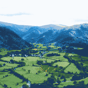
Protected nature does not come one designation at a time. This is a real point in Borrowdale: a national park, a national nature reserve, two Special Areas of Conservation, an SSSI and ancient woodland cover the same ground, and each carries its own legal regime with its own consent rules. Miss one and a desk study is wrong.
Borrowdale, the Lake District · point=54.52,-3.15
GET /v1/conservation?point=54.52,-3.15&radius=250

{
  "type": "national_park",
  "name": "Lake District",
  "designated": "1951",
  "area_ha": 236234,
  "custodian": "Natural England"
}

→ layer 1 of 6 in this response
GET /v1/conservation with a point returns every layer that covers it in one response, widest first. Six layers here, one payload. The answer is the stack, not the nearest match.
The reconciliation
Natural England, NatureScot, Natural Resources Wales and Northern Ireland's DAERA each notify and map their own sites, in their own formats, on two different national grids, with their own update cycles. We reconcile all four into one schema, give every designation a stable identifier, and track changes as the custodians revise their registers.
Natural England
England · EPSG:27700
NatureScot
Scotland · EPSG:27700
Natural Resources Wales
Wales · EPSG:27700
DAERA
Northern Ireland · EPSG:29903
id           stable across register revisions
designation  the nation's own term, never translated
geometry     EPSG:4326, reprojected from both grids
attribution  the statutory body, on every record
Designations are never translated. Northern Ireland's ASSI stays an ASSI, because presenting it as an SSSI would misstate the law that protects the land.
The alternative
Without the API, conservation data is a project. Twenty-four designation types from four statutory bodies, each published its own way. Downloads that start going stale the day you fetch them. Reprojection from two national grids. MultiPolygons that arrive broken and need repair. Then a site is notified or a boundary amended, and your copy is quietly wrong.
What you'd build
fetch
Twenty-four designation types from four statutory bodies, each published its own way.
reproject
British National Grid and Irish Grid into WGS84, without smearing a boundary.
repair
MultiPolygons that arrive self-intersecting and break spatial queries.
reconcile
Overlapping designations resolved per point: SSSI under SAC under national park.
watch
Notifications, amendments and denotifications, every cycle, forever.
host
The database, the spatial index and the uptime.
…every cycle, forever. Or:
What you call
We run that pipeline so you don't have to. Ingest, reconciliation, geometry repair and serving all happen on our infrastructure. You call one endpoint, and the stale-copy problem is ours.
GET /v1/conservation?point=54.52,-3.15&radius=250

→ 200 OK · 6 designations, one stack

geometry      EPSG:4326, repaired, valid
regimes       the law named on every record
attribution   inline, the statutory body named
provenance    snapshot and source dates, on every response
Everything on the left, already done.
This is infrastructure, not a download. We run the pipeline; you build the product.
The record
A stable identifier, the exact statutory regime, the custodian's own condition wording, the boundary as EPSG:4326 geometry, and Natural England's attribution inline. The record repeats the register rather than paraphrasing it.
Borrowdale Woodland Complex
Natural England · Lake District, Cumbria
The cycle
Designations move. Sites are notified and denotified, boundaries are amended, habitats are remapped. A shapefile you downloaded in the spring knows none of this.
2026-06-11 · register release
Natural England amends a site notification
vco_des_01J9RWFN · boundary amended
2026-06-13 · ingested
fetched 02:47:31Z · reconciled · geometry validated
re-served under the same id vco_des_01J9RWFN
2026-06-18 · your next call
"id": "vco_des_01J9RWFN"
"snapshotId": "conservation-20260618-01"
"releaseDate": "2026-06-11"
"fetchedAt": "2026-06-13T02:47:31Z"
You never host a copy, so you never host a stale one.
The datasets
Coverage follows what the statutory bodies publish. Each dataset page carries its own coverage, sources and schema, including what is not there yet.
SSSIs in England and Wales and Northern Ireland's ASSIs. Scotland's are next, and we say so.
View dataset →02Habitats and species of European importance, all four nations.
View dataset →03Sites classified for rare, vulnerable and migratory birds, all four nations.
View dataset →04Wetlands of international importance, listed under the Ramsar Convention.
View dataset →05Woodland on the inventories since 1600 in England and Wales, 1750 in Scotland.
View dataset →06The national parks of England and Wales, as designated boundaries.
View dataset →07National Landscapes, AONBs and Scotland's National Scenic Areas.
View dataset →08Habitat parcels for biodiversity and BNG screening, all four nations.
View dataset →09Marine Conservation Zones and Scotland's Marine Protected Areas.
View dataset →10National and Local Nature Reserves, each served as its own type.
View dataset →The API
Conservation answers the same location queries as the rest of the platform. Point, radius, bounding box or polygon, or a single designation by its identifier. One key, one schema, all four nations.
One call returns everything protecting a point. Over Borrowdale that is six overlapping designations, from the national park down to the woodland parcel — the same stack the plate above draws.
GET /v1/conservation?point=54.52,-3.15

{
  "count": 6,
  "results": [
    {
      "id": "vco_des_01J9RTK2",
      "type": "national_park",
      "name": "Lake District"
    },
    {
      "id": "vco_des_01J9RSXE",
      "type": "national_nature_reserve",
      "name": "Borrowdale Rainforest"
    },
    {
      "id": "vco_des_01J9RQWD",
      "type": "sac",
      "name": "Borrowdale Woodland Complex"
    },
    {
      "id": "vco_des_01J9RVN8",
      "type": "site_of_special_scientific_interest",
      "name": "Borrowdale Woodland Complex"
    },
    {
      "id": "vco_des_01J9RWKM",
      "type": "ancient_woodland",
      "name": "Johnny Wood"
    },
    {
      "id": "vco_des_01J9RXDQ",
      "type": "sac",
      "name": "River Derwent & Bassenthwaite Lake"
    }
  ]
}
The use cases
One API, four jobs. Each of these is a question the API answers in one request.
Desk studies
One point query returns the stack: SSSI, SAC, SPA, Ramsar, ancient woodland, each layer naming its statutory regime.
GET /v1/conservation?point=54.52,-3.15
HRA screening
Radius queries return the SACs, SPAs and Ramsar wetlands around a plan or project: the trigger list for a Habitats Regulations assessment.
GET /v1/conservation?point=...&radius=5000&types=sac,spa,ramsar
BNG and land tools
Polygon queries return habitat parcels with area computed from the geometry, ready for biodiversity net gain screening and land management products.
POST /v1/conservation/query · types=priority_habitat
Statutory bodies and LPAs
Publishing through the standard routes is the whole job. The layers arrive here hosted, versioned and queryable, alongside every neighbouring authority's. No GIS server to procure, no API to run.
One stack, served at /v1/conservation
Your GIS team has better things to do than stitch four custodians' registers back together every quarter.
The guarantees
Licence
Open Government Licence sources, with each record carrying its register's licence terms inline.
Attribution
The custodian is named on every record, so attribution is never guesswork.
Provenance
Every response names its snapshot, the custodian's release date and the moment we ingested it.
Layering
Every designation at a point comes back in one response, each under its own stable id.
